


10364666-Oingt les pierres dorées

gdela
User
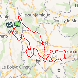

Length
21 km

Max alt
650 m

Uphill gradient
685 m
Km-Effort
30 km

Min alt
287 m

Downhill gradient
681 m
Boucle
Yes
Creation date :
2019-09-08 17:36:11.352
Updated on :
2019-10-01 09:38:27.259
--
Difficulty : Difficult

FREE GPS app for hiking
 SityTrail
IGN / Geographical institutes
SityTrail Plus
The world is yours!
About
Trail On foot of 21 km to be discovered at Auvergne-Rhône-Alpes, Rhône, Val d'Oingt. This trail is proposed by gdela.
Positioning
Country:
France
Region :
Auvergne-Rhône-Alpes
Department/Province :
Rhône
Municipality :
Val d'Oingt
Location:
Oingt
Start:(Dec)
Start:(UTM)
622693 ; 5089684 (31T) N.
Comments